

")
")


Peter J.M. van Oosterom and Marc. J. van Kreveld (Editors)
Nederlandse Commissie voor Geodesie 44, Delft, 2006. 62 pagina's.
ISBN-13: 978 90 6132 299 3. ISBN-10: 90 6132 299 5.
Editorial
Geographic Information Science (GIS) is a multi-disciplinary research area. Contributions from the spatial sciences come from geodesy, geography, and cartography, whereas contributions from computer science come from databases, artificial intelligence, and computational geometry. Furthermore, very different research areas where GIS are used, like spatial planning, archaeology, geology, civil engineering and biology, also perform applied research in GIS.
Computational geometry is all about doing geometric computations by the computer. For this, (additional) theory is being developed based on the foundation of mathematics. Data structures and algorithms are developed to solve geometric problems often with proven worst-case (and some times also with other) time and memory bounds. Computational geometry techniques can be, and are applied in many different domains: vision, path planning, gaming, graphics, robotics, medical image processing, and of course also in GIS.
The seminar 'Geo-Information and Computational Geometry' of the Netherlands Geodetic Commission (jointly organized with Geo Informatie Nederland) was devoted to the relationships between GIS and computational geometry. In a GIS, computations with coordinates are needed, whereas computational geometry is about developing methods to do so. The seminar aimed to improve the understanding of the two research fields, so that interaction in the future is further strengthened. We hope that the study day has resulted in lasting new contacts between all people in the Netherlands with an interest in geometric computing in GIS.
The contributions reflect the diversity of the possible interactions between computational geometry and GIS. The topics of the contributions range from overviews of relevant techniques and tools to solving specific spatial problems in either the object-based (vector) or field-based (raster) domain. This publication is a reflection of the different seminar contributions.
The first paper 'Computational Geometry: Its objectives and relation to GIS' is by Marc van Kreveld (Utrecht University). The analysis of algorithms involves understanding how efficiently an algorithm solves a problem. One of the main objectives of computational geometry is finding the most efficient algorithms for all sorts of geometric problems. He introduces the main concepts and ideas in computational geometry, including efficiency analysis, intractability, output-sensitive algorithms, and approximation algorithms. The basic problems of computational geometry all have a direct or indirect use to GIS. He also indicates why computational geometry is not as useful to GIS as it could be (complicated algorithms, focus on worst-case efficiency, and on well-defined, simple to state problems) and how this is currently improving (available software libraries, simpler algorithms provably efficient under realistic assumptions).
Mark de Berg (TU Eindhoven) addresses one of the issues to make computational geometry techniques more applicable in practice, namely the handling of large data sets that do not fit in main memory (as often more or less implicitly assumed in the description of many data structures and algorithms). In his paper 'I/O- and Cache-efficient Algorithms for Spatial Data' he explains how the hierarchical memory consisting of a disk, main memory, and several levels of cache should be included in data structure and algorithm design. The difference between the times to access these different levels of memory is quite large: the disk is typically about 100,000 times slower than accessing the main memory. In the paper some of the recent results that have been obtained on I/O- and cache-efficient algorithms are discussed with focus on spatial data.
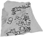
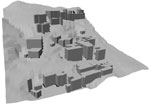
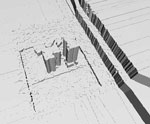
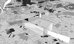
One specific data structure, based on quad-edges, and applied to creating and editing three-dimensional models, is described by Christopher Gold and Rebecca Tse (University of Glamorgan, UK) in their paper 'Quad-Edges and Euler Operators for Automatic Building Extrusion Using LiDAR Data' (LIght Detection And Ranging). The long-term research objective for their models is to integrate man-made objects with the landscape, so that topological properties, such as connectedness, may be used in applications such as flood modeling. Man-made objects such as buildings, as well as terrain elevation, should be extracted directly from LiDAR data. Their model is a triangle-based boundary description of the relevant objects and earth surface. The model creation and local modifications (updates) is performed on the Quad-Edge data structure by using Euler operators. These operators permit various extrusion operations as well as the manual insertion of bridges and tunnels.
A description of the use computational geometry tools used to solve a few specific cartographic problems is given by Bettina Speckmann (TU Eindhoven) in her paper 'Algorithms for cartograms and other specialized maps'. Cartograms are a useful and intuitive tool to visualize statistical data about a set of regions like countries, states or counties. The size of a region in a cartogram corresponds to a particular geographic variable and therefore the regions generally cannot keep both their shape and their adjacencies. A good cartogram, however, preserves the recognizability in some way. The paper gives a short overview of cartogram algorithms, and focuses in particular on the computation of rectangular cartograms. In a rectangular cartogram each region is represented by a rectangle. An implementation and various tests show that in practice, visually pleasing rectangular cartograms with small cartographic error can be generated effectively. Furthermore, the computation of proportional symbol maps is also discussed briefly.
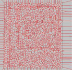
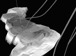
Three-dimensional topographic modeling is also the topic of the paper by Friso Penninga (TU Delft): 'Constrained tetrahedral models and update algorithms for topographic data'. In contrast to the work of Gold and Tse he does not do this by representing the bounding surfaces, but he represents the three-dimensional objects by sets of tetrahedrons. The whole model then becomes a tetrahedronized irregular network (TEN), the 3D version of the more generally known triangulated irregular network (TIN). The TEN is a well-defined and robust data structure which enables complex processing by separate processing on each primitive first and afterwards joining all these partial results into a final result. In order to represent their borders several edges and faces will be handled as constraints. Updating a topographic dataset therefore equals the addition and removal of constraints within the network. One of the biggest challenges in the realization of such a data structure and corresponding algorithms is to reach acceptable performance, despite the potentially enormous amount of data.
The last paper 'Towards improved solution schemes for Monte Carlo simulation in environmental modeling languages' is by Derek Karssenberg and Kor de Jong (Utrecht University). They deal with the field-based representation of spatial data, in contrast to the object-based representation of spatial data in the other papers. On the most often used field-based data structure, the regular grid, the algorithmic challenges are quite different than their counterparts in the object-based approaches. Environmental modeling languages such as PCRaster are programming languages embedded in GIS to simulate environmental processes. These languages are used to construct dynamic models, also called forward models, which are simulations run forward in time, where the state of the model at time t is defined as a function of its state in a time step preceding t. For future applications, at least two extensions to the languages are required: support of three spatial dimensions (as the real world is often 3D), and inclusion of Monte Carlo simulation techniques (to calculate how input errors propagate to the output of a model).
The seminar day was organized by the Subcommittee Geo-Information Models of the Netherlands Geodetic Commission, and was held at Utrecht University on November 14, 2005. We wish to thank the sponsors of the seminar as well for helping to make the day free of costs for all participants. These sponsors are the Netherlands Geodetic Commission, Geo Informatie Nederland (GIN), the Department of Information and Computing Sciences of Utrecht University, and the section GIS technology at the Delft University of Technology. We are further grateful to Frans Schröder for his support in setting up the seminar, but also for the realization of this publication. Finally, we hope that this publication will help to increase the collaboration between computational geometry and GIS. We express our thanks to all speakers at the seminar, as they are the main contributors to this publication, and the participants for the lively discussions at the seminar.
The editors, Peter van Oosterom and Marc van Kreveld
Content
Editorial vii
Peter van Oosterom and Marc van Kreveld
Computational Geometry: Its objectives and relation to GIS 1
Marc van Kreveld
I/O- and Cache-Efficient Algorithms for Spatial Data 9
Mark de Berg
Quad-Edges and Euler Operators for Automatic Building Extrusion Using LIDAR Data 17
Christopher Gold and Rebecca Tse
Algorithms for cartograms and other specialized maps 26
Bettina Speckmann
Constrained tetrahedral models and update algorithms for topographic data 35
Friso Penninga
Towards improved solution schemes for Monte Carlo simulation in environmental modeling languages 43
Derek Karssenberg and Kor de Jong