

")
")


| Date: | 21 november 2019 |
| Time: | 09:30 - 17:20 |
| Location: | TU Twente/ ITC, Hengelosestraat 99, 7514 AE Enschede |
| Registration: | required: Dit e-mailadres wordt beveiligd tegen spambots. JavaScript dient ingeschakeld te zijn om het te bekijken. |
 Op 21 november organiseerde het NCG zijn jaarlijkse symposium bij de universiteit Twente. Bijgevoegd vindt u het programma en de samenvattingen van de presentaties die gegeven werden.
Download bijlagen: Abstracts NCG Symposium 2019
Programma NCG symposium op 21 november 2019 bij de U Twente/ ITC, Hengelosestraat 99, 7514 AE Enschede:
| 09:30 | Registration and Coffee/tea | |
| 10:00 | Opening by Prof. Dr. Ir. A.K. Bregt chair of the NCG | |
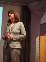
| 10:10 | Baarda Lecture by Prof. Dr.-Ing. habil. M. Sester of the Leibniz University Hannover, Institute of Cartography and Geoinformatics. | |
|
Titel of the lecture "Monitoring cities with modern sensors and analysis methods" Download lecture: |
||
| 11:00 | Start of the PhD abstract presentations, part 1 | |
| 12:20 | Lunch | |
| 13:30 | PhD abstracts part 2 | |
| 14:50 | Coffee/tea break | |
| 15:30 | PhD abstracts part 3 | |
| 16:50 | Drinks |
Presentations of the PhD abstracts
!!!! The abstracts "Point Clouds" in room 2-108 (11:00 - 12:00) are back and forth exchanged to/transfered towards room 2-140 "Geo Ethics/critical data science"(15:50 - 16:50)
| Room 2-108 | Point Clouds | ||||
| 11:00 | Y. Zang | TU Delft | An improved Coherent Point Drift method for TLS point cloud registration of complex scenes | ||
| 11:20 | L.Truong-Hong | TU Delft | Automatic decomposition of bridge structural compenents from a terretrial laser point cloud | ||
| 11:40 | S.Karam | U Twente | Integrating a low-coast MEMS IMU in laser-based SLAM for indoor mobile mapping | ||
| Remote Sensing Applications | |||||
| 12:00 | M.Koeva | U Twente | Innovative remote sensing applications to support land tenure mapping in Kenya | ||
| 13:30 | S.Lobry | WUR | Visual question answering from Remote Sensing Images | ||
| 13:50 | Y.Lyu | U Twente | UAVid: A Semantic Segmentation Dataset for UAV Imagery | ||
| Modelling | |||||
| 14:10 | A.Shnaidman | TU Delft | LADM refined survey model | ||
| 14:30 | A.Alattas | TU Delft | LADM-IndoorGML for exploring user movements in evacuation exercise | ||
| 15:30 | M. Garciaalvarez | U Twente | A language for the definition and detection of geographic events using sensor networks and event processing | ||
| Visualisation | |||||
| 15:50 | D.Peng | TU Delft | Finding parallel events of aggrigating land-cover parcels to support smoothe zooming | ||
| 16:10 | I. Dobraja | U Twente | Dashboard adaptability in virtual reality (VR) environment illustrated with origin destination data | ||
| 16:30 | M.Wang | U Twente | Road network structure and e-hailing accessibility | ||
| Room 2-140 | Machine Learning for GIS Science | ||||
| 11:00 | Y.Lin | U Twente | Efficient Training of Semantic Point Cloud Segmentation via Active Learning | ||
| 11:20 | S.Srivastava | WUR | Adaptive Compression-based Lifelong Learning | ||
| 11:40 | M.Kuschnerus | TU Delft | Unsupervised Learning on Time Series from Permanent Laser Scan Data | ||
| 12:00 | G.Fu | U Twente | A deep-learning-based approach for fast and robust steel surface defects classification | ||
| 13:30 | C.Valk | NEO | Roof change detection with DL using artificial training data for asbestos monitoring | ||
| 13:50 | M.Sales | WUR | Better land cover class area estimates using Random Forest’s class probabilities: a case study using a big dataset in the Amazon. | ||
| 14:10 | Z.Yang | U Twente | The classification of ALS point clouds with the use of a 2D vector data map | ||
| GNSS /SAR | |||||
| 14:30 | H.Dun | TU Delft | Precise ranging using sparse multiband radio signals | ||
| 14:50 | !!! | F.Mirmohamadian | TU Delft | Generate virtual observations applying geometriccorrections to the IGS stations | |
| 15:30 | M. Manne | TU Delft | Phase inconsitencies in SAR interferometric triplets | ||
| Geo Ethics / critical data science | |||||
| 15:50 | Y.Georgiadou | U Twente | Space for ethics I | ||
| 16:10 | O.Kounadi | U Twente | Space for ethics: A course curriculum to examine, analyze, and protect Geoinformation Disclosure | ||
| 16:30 | C.Gevaert | U Twente | Space for ethics: Towards the development of Fair, Accountable, and Transparent algorithms for Remote Sensing | ||
| Room 2-142 | 3D Dimension | ||||
| 11:00 | K. Zhou | TU Delft | LiDAR-guided Edge-aware Dense Matching on Multi-view Images for Creating a Up-to-date 3D City Model | ||
| 11:20 | H.Liu | TU Delft | Realistic 3D/4D perspective view selection on massive points | ||
| 11:40 | W.Gao | TU Delft | 3D mesh annotat ion : Towards large scale semantic 3D urban mesh benchmark | ||
| 12:00 | E.Kalogianni | TU Delft | 3D Cadastre within objects' spatial development lifecycle | ||
| Crowd, citizen, Assessment | |||||
| 13:30 | A.Levering | WUR | Lessons Learned from Using Geotagged, Crowdsourced Image Data for Detecting Road Accidents | ||
| 13:50 | F.Hoefsloot | U Twente | Space for ethics: Making consumer-citizens: the datafication of Lima’s water infrastructure | ||
| 14:10 | W.Supinajaroen | TU Delft | Building an Assessment Framework for Continuously Operating Reference Station Implementation | ||
| 14:30 | M.Kuffer | U Twente | People–Pixels–Privacy: Can gridded datasets protect the privacy of inhabitants in deprived areas? | ||
| Monitoring change | |||||
| 15:30 | H.Velsink | H Utrecht | Deformation analysis with a hypothesis constrained multi-epoch analysis | ||
| 15:50 | A.Kulshrestha | U Twente | On the detectability of subsidence patterns over simulated sinkholes using time series INSAR techniques | ||
| 16:10 | R.Toodesh | TU Delft | Functional model selection for predicting the changes in seaflor depths | ||
| 16:30 | M. Kleinherenbrink | TU Delft | The performance of Harmony's sea-ice drift observations | ||